WELCOME to THE GREEN HISTORY DETECTIVES
Episode 20
The buttons above images are identified and described below:
BUTTON
DESCRIPTION
CHANGE
Change to the other image in the set
ZOOM IN
Zoom into image
NORMAL
Restore image to initial size
ZOOM OUT
Zoom out of image
Repeating an operation is most effectively performed by clicking
on a button and then pressing the enter key repeatedly as desired.
Panning is most effectively performed by using the cursor keys.
The error is identified and reported in the email message below that was sent to the folks at the
Ohio Historical Society and the State Library of Ohio who are apparently responsible for the Ohio
Memory and Ohio History web pages. Note that the Zoom and Pan feature was not available in the
email message but are provided for visitors of this web page.
Ohio Historical Society and State Library of Ohio:
The Ohio Memory and Ohio History Internet web sites are greatly appreciated.
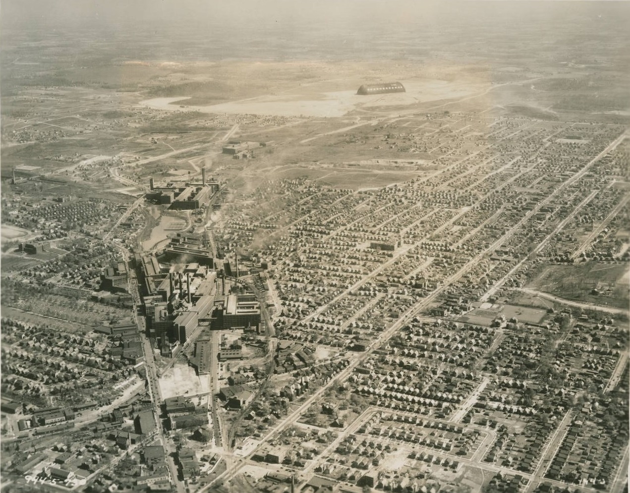
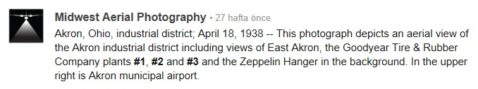
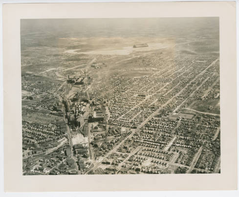
The aerial photo below is of the southeast area of Akron, Ohio and resides on several
Ohio Memory and Ohio History web pages and others:
The web pages listed below include the aerial photo above along with a description that
includes the sentence: “In the upper right is Akron municipal airport.”:
Evidently, that sentence is erroneous and needs to be changed
FROM: "In the upper right is Akron municipal airport."
TO: "In the left is Akron municipal airport."
That is, the words "upper right" need to be changed to the word "left".
More accurately, the sentence may be changed to:
"Between the Zeppelin Hanger and the left edge of the photograph is the Akron
Municipal Airport."
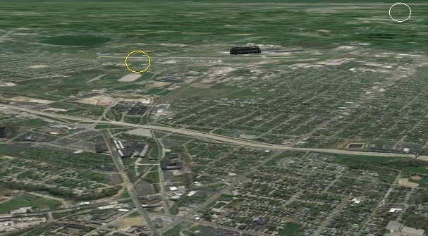
In the black circle below, between the Zeppelin Hanger and the left edge of the photograph, is the
Akron Municipal Airport Terminal:
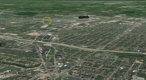
In the yellow circle below, between the Goodyear Airdock (known earlier as the Zeppelin Hanger) and
the left edge of the recent aerial photograph, is the original Akron Municipal Airport Terminal:
Original Akron Municipal Airport Terminal:
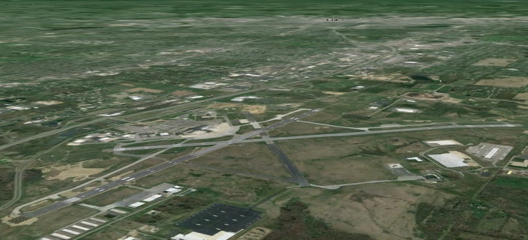
In the upper right of the recent aerial photo below is the Akron-Canton Airport circled in white:
The area below of the Akron-Canton Airport is in the white circle above:
Akron-Canton Airport:
Is it possible that the description "In the upper right is Akron municipal airport" on
the web pages above are referring to the Akron-Canton Airport instead of the Akron
Municipal Airport?
That is not likely because the Akron-Canton Airport did not open till 1946 and the old aerial photo
was taken in 1937 or 1938, long before the Akron-Canton Airport existed.
We would like to know if the sentence "In the upper right is Akron municipal airport."
is indeed incorrect and that the words "upper right" need to be changed to the word "left"
or, more accurately, that the sentence should be changed to:
"Between the Zeppelin Hanger and the left edge of the photograph is the Akron
Municipal Airport."
This email message is also attached in the Microsoft Word file ThisOldBuilding.doc.
If you have any questions or comments, please do not hesitate to contact me at: TDBConsulting@aol.com
The old aerial photo and the Google Earth image may be compared by using the CHANGE button below
Apparently, a wide angle lens was used when the old aerial photo was taken which would account for
the different widths.
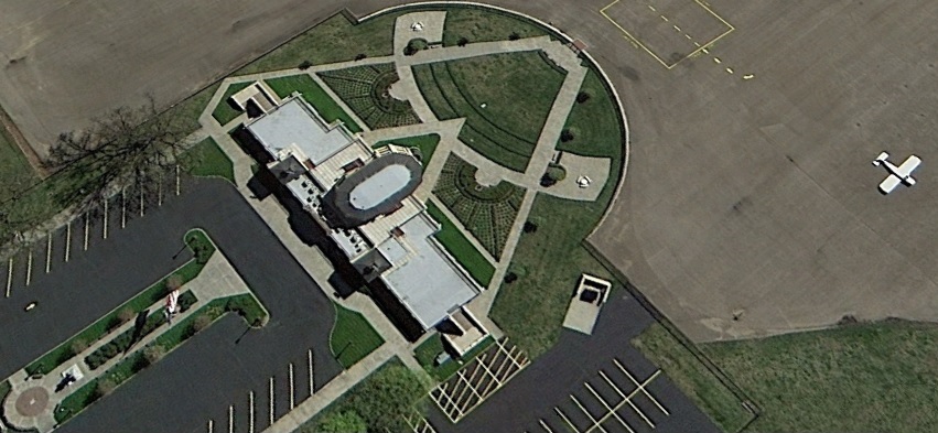
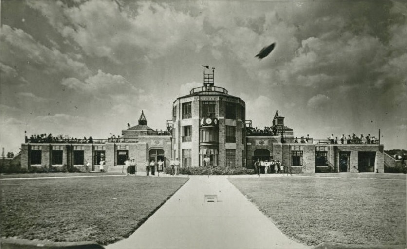
The original terminal at the Akron Municipal Airport, more accurately known as the Akron-Fulton
International Airport, is located at 1800 Triplett Boulevard in Akron, Ohio. Specifically, the
terminal is located at: Latitude: N41°02'31.9", Longitude: W81°27'46.8", Elevation: 1,067 feet Mean Sea Level (MSL).
It is an "International Airport" because it has United States Immigration and Customs Enforcement
facilities. Airport construction began in 1928 after the Goodyear Zeppelin company was awarded the
Navy contract to build the airships USS Akron and USS Macon. For more information about the
Goodyear Airdock, USS Akron, and USS Macon, refer to
Episode 19.
Airport construction completed in 1929 and construction of the terminal completed in June 1931 at
a cost of $120,000. Note that this photo is of the south side of the building:
Fulton is included in the name because Bain Ecarius "Shorty" Fulton sold the land for the airport
to Akron in 1925 and then later managed the airport. Mr. Fulton also helped to establish the Derby
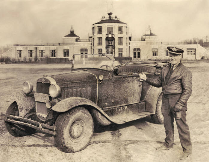
Downs and the Rubber Bowl. Below is a 1933 photo of Mr. Fulton, a Model A Ford, and the Akron-Fulton
Airport Terminal. Note that this photo is of the south side of the building:
Commercial airline service at the Akron-Fulton Airport ended in 1948 (or in 1962 according to some
sources) after the Akron-Canton Airport opened.
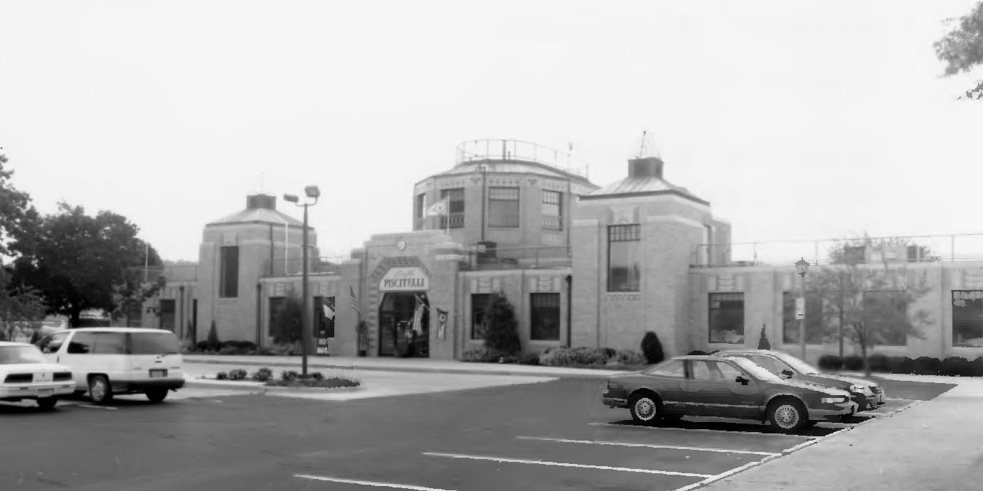
In 1983, Cafe Piscatelli Italian Restaurant purchased the Terminal building which then served as
a restaurant as shown in the photo below. Note that this photo is of the north side of the building:
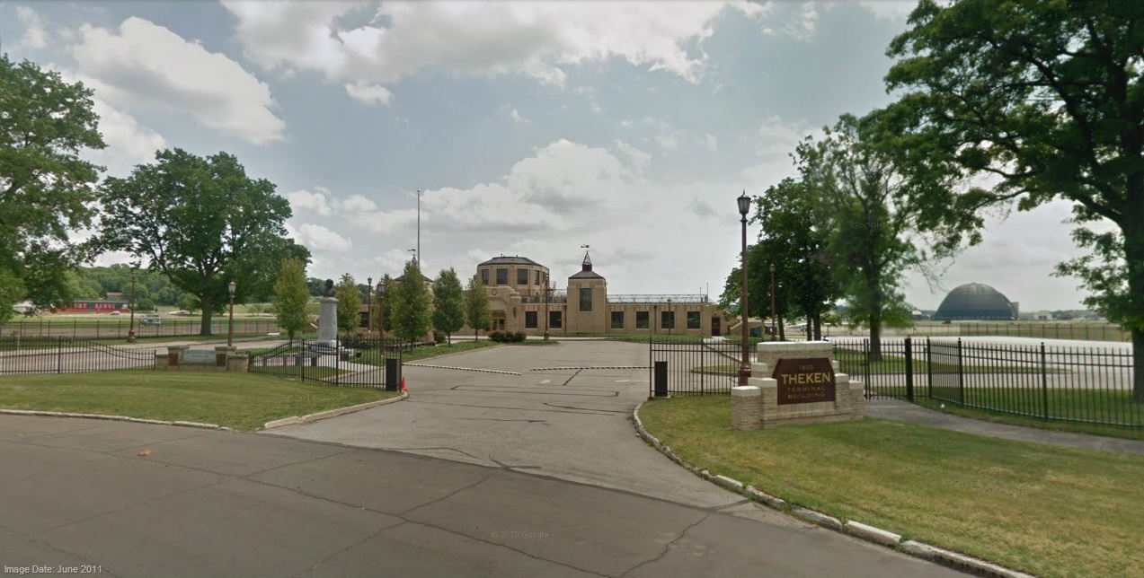
In 2005, Theken Spine Medical Products purchased and restored the Terminal building to serve as
their company headquarters as shown in the photo below. Note that this photo is of the north side
of the building:
In 2011, after Theken was purchased by Integra LifeSciences in 2008, Theken moved operations to
Medina County and the Terminal building has been vacant since then.
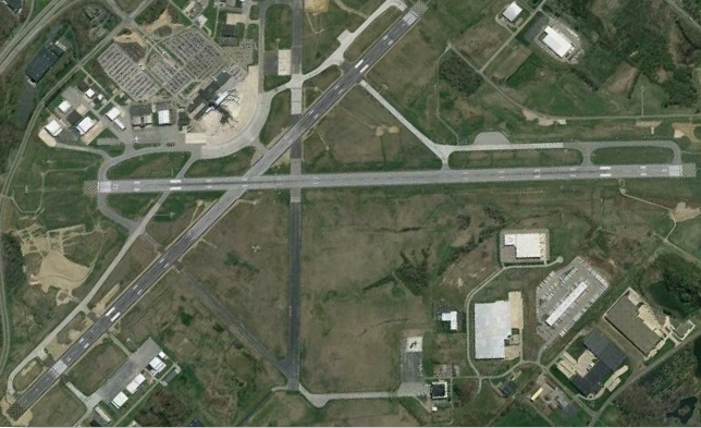
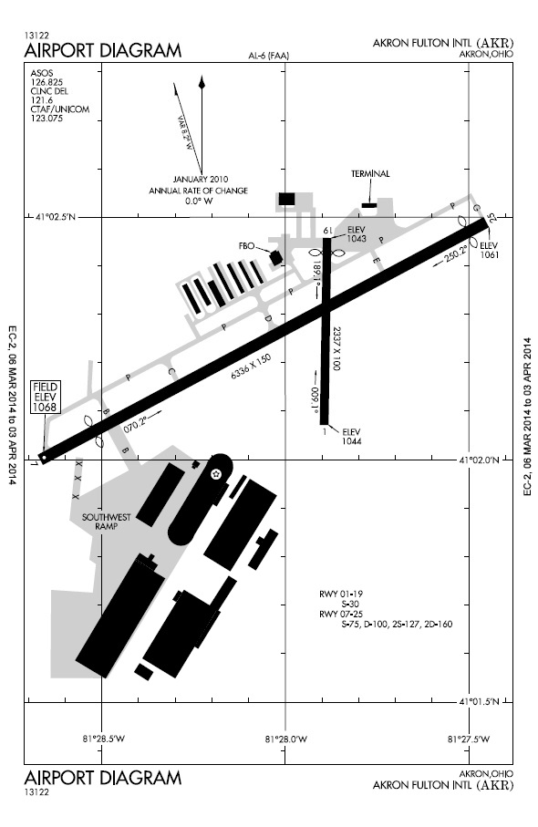
The Akron-Fulton Airport is now used for cargo and private aircraft and it has two asphalt runways:
Runway 07/25 is 6,336 feet long and 150 feet wide.
Runway 01/19 is 2,337 feet long and 100 feet wide.
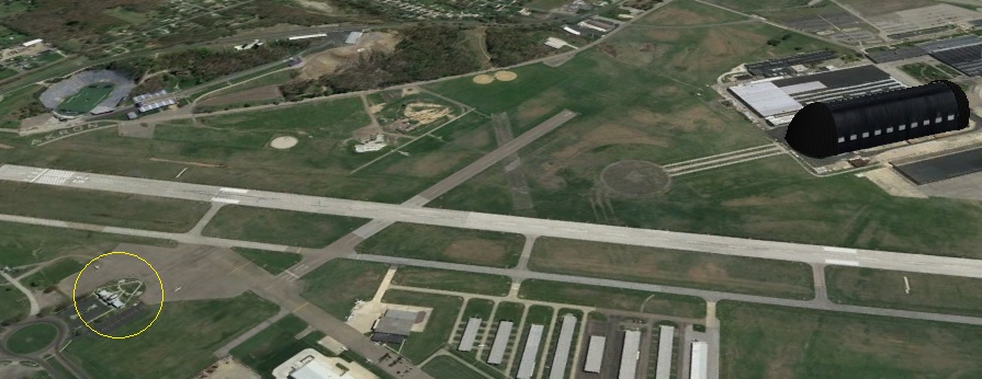
The Airport Diagram and recent aerial photo are given below and include the Goodyear Airdock.
The two images may be compared by using the CHANGE button:
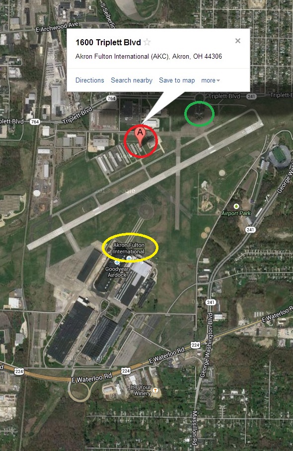
ISSUE #1: QUESTION
Where's The Akron-Fulton International Airport Terminal?
The present Airport Diagram (Effective March 6, 2014 to April 3, 2014) above shows the current
terminal located where the original terminal was located.
However, the recent Google Maps aerial photo above shows "Akron-Fulton International" right next to
the Goodyear Airdock and has an address of 1600 Triplett Boulevard Akron, OH.
However, entering 1600 Triplett Boulevard Akron, OH in a Google Maps search identifies the facility
north and west of the runways.
QUESTION:
When one is to go to the Akron-Fulton International Airport, to which of the following locations
does one go?
To the original Terminal building as shown in the Airport Diagram at
1800 Triplett Boulevard and circled in green below.
Right next to the Goodyear Airdock as circled in yellow below.
1600 Triplett Boulevard as circled in red below.
Other (i.e. None of the above)
The answer will be provided when those who have been contacted respond.
The Akron-Canton Airport has two asphalt runways:
Runway 05/23 is 8,204 feet long and 150 feet wide.
Runway 01/19 is 7,601 feet long and 150 feet wide.
For information about the history of the Akron-Canton Airport, refer to the web page Akron-Canton Airport History.
The response from Ohio Memory and the Ohio Historical Society to the email message sent to them
above about the aerial photo description is given below:
Hello Mr. Ball,
Thank you for contacting Ohio Memory and the Ohio Historical Society about the
information included in the record for this historic aerial photograph. Based on the
images you included in your message, as well as additional photographs available through
the website Summit Memory, we have confirmed that the caption should identify the Akron
Municipal Airport in the upper left quadrant of the photograph, rather than the upper
right. We have gone ahead and made this correction to the record, which can now be viewed
here: http://www.ohiomemory.org/cdm/ref/collection/p267401coll34/id/7958.
The changes are also active for the copy of the photograph available through OhioPix.
However, we have no affiliation with the Pinterest account linked below, and therefore
cannot update the information available on that site.
We appreciate your input to help ensure the accuracy of our image descriptions, and are
glad have found these websites to be valuable resources. Thanks again for your
contribution, and we hope you continue to enjoy the digital collections on Ohio Memory!
Best,
Lily Birkhimer | Assistant Curator, Digital Services
Ohio Historical Society | 800 E. 17th Ave. Columbus, Ohio 43211
PART 2:
Who can tell us what the error(s) is (are) that now exist(s) after the Ohio Historical Society
acknowledged and corrected the initial error on their web pages as identified and reported in
PART 1 above?
The response to the email message above is given below.
page.
Hello Lily:
Thank you for your swift response.
I noticed that the following portion of the aerial photo description has been changed FROM (red text is text removed for the TO):
This photograph depicts an aerial view of the Akron industrial district including views
of East Akron, the Goodyear Tire & Rubber Company plants #1, #2 and #3, and the Zeppelin
Hangar in the background. In the upper right is Akron municipal airport. The B.F. Goodrich
Rubber Company Plant was located at 500 South Main Street was Akron’s oldest rubber
factory and one of the world’s largest, producing more than 30,000 kinds of rubber
articles beside automobile tires.
TO (green text is text added to the FROM):
This photograph depicts an aerial view of the Akron industrial district, including views
of East Akron, the Goodyear Tire & Rubber Company plants #1, #2 and #3, and the Zeppelin
Hangar (later known as the Goodyear Airdock) in the background. In the upper left quadrant
of the photograph, to the left of the airdock, is Akron Municipal Airport. Akron Municipal
Airport began operating in 1924 on property belonging to Bain Ecarius "Shorty" Fulton, and
was later renamed Akron Fulton International Airport in his honor. The B.F. Goodrich
Rubber Company Plant, located at 500 South Main Street, was Akron’s oldest rubber factory
and one of the world’s largest, producing more than 30,000 kinds of rubber articles
besides automobile tires.
The United States Department of the Interior National Park Service NATIONAL REGISTER OF
HISTORIC PLACES REGISTRATION FORM for the Akron-Fulton International Airport
Administrative Building (i.e. Terminal), entered 12/21/2001, is provided at http://sc.akronlibrary.org/files/2011/11/01001361.pdf.
Based on that and information from other sources, my understanding is that Fulton was
always included in the name because Bain Ecarius "Shorty" Fulton sold the land for the
airport to Akron in 1925 and then later managed the airport, for which construction
completed in 1929 and construction of the terminal completed June 15, 1931.
“The Akron Municipal Airport terminal in Akron, Ohio. In 1924 Bain Ecarius "Shorty"
Fulton bought a farm on Massillon Road, and, after clearing his pasture and orchard,
began operating what was to become the Akron Municipal Airport. The Akron Municipal
Airport was later renamed the Akron Fulton International Airport in his honor.The Akron
Municipal Airport terminal in Akron, Ohio.”
The way the description is worded above, it is possible to interpret that as meaning the
following:
In 1924, Mr. Fulton bought the farm and in that same year began operating the farm, which
later became the Akron Municipal Airport.
However, as indicated previously by other sources, Mr. Fulton evidently sold the land for
the airport to Akron in 1925 and then later managed the airport, which began operation in
1929. Then, on June 15, 1931, the airport terminal opened.
It may be worthy to note that the description on the Summit Memory web page about the
post card gives the sentence “The Akron Municipal Airport terminal in Akron, Ohio.” twice:
once at the beginning of the description and once again at the end, which is missing a
space between the period after the word “honor” and the final sentence.
“He managed the municipal airport for 34 years until retiring in 1962. Son Bain J. "Bud"
Fulton succeeded him as superintendent. In 1978, the City Council renamed the airport
Akron Fulton in their honor. Shorty Fulton died in 1979 at age 87.”
However, I have not found any other source of information that indicates that the airport
was “renamed” to include the word “Fulton”.
Questions:
Was the airport always known as (and not “later renamed” to) Akron-Fulton International
Airport?
Is it true that the airport began operation in 1929 (and not 1924)?
This email message is also attached in the Microsoft Word file ThisOldAerialPhoto2.doc.
Thank you for your time and efforts,
Tim
The response to the email message above is given below.
Hello Tim,
Thank you for this further clarification. Based on the information available on the NRHP
information sheet, it seems to me that the site was originally known as the Akron
Municipal Airport (or Air Terminal) when it first started operations. This is the name
referred to both on the “Continuation Sheet,” as well as on the early maps provided as an
addendum to the document. At some point it changed from a transcontinental to
international airport, and to its current name as listed on the registration form, the
Akron-Fulton International Airport. From what I have found, the renaming happened
sometime between 1975 and 1979—I am basing this on the finding aid of the Bain Fulton
Collection from the Akron-Summit County Public Library, which includes a timeline and
several other references to the name change.
I have already corrected the operation date, but if you have any further insight into the
name, I will be happy to hear it and make the necessary changes. Also, I should mention
that Summit Memory is a separate project from Ohio Memory, maintained by a consortium of
partners in the Akron-Summit area and administered by the ASCPL. We have no control over
the content available through that site, but contact information for its organizers is
available here:
http://www.summitmemory.org/cdm/aboutsummitmemory.
Thank you again for your interest in Ohio Memory, and for your help in ensuring the
accuracy of our records!
Best,
Lily
The response to the email message above is given below.
Hello Lily:
Thank you for the information.
In an effort to verify and clarify historical information about the Akron Fulton
International Airport, the following message has been sent to the Akron City Council
members at: http://www.akroncitycouncil.org/Contact_Council/
Akron City Council:
I have three (3) questions about the Akron Fulton International Airport that I hope you
can answer to verify and clarify historical documentation:
QUESTION #1:
What was the date that Akron City purchased the land from Bain E. Fulton on which the
Akron Municipal Airport was built?
The web page at: http://ibmag.com/Main/Archive/No_Plane_No_Gain_9084.aspxs
states that:
“In the early '80s, almost 150 airplanes were based at Akron- Fulton, named for Bain E.
Fulton, who in 1925 sold Akron the land on which the airport was built.”
QUESTION #2:
What was the date that Akron City Council renamed the Akron Municipal Airport to Akron
Fulton International Airport?
The web page at: http://ead.ohiolink.edu/xtf-ead/view?docId=ead/OAk0003.xml;chunk.id=bioghist_1;brand=default
states that:
“Akron Municipal Airport name changed to Akron Fulton Airport in honor of Fulton and his
son, Bain J. "Bud" Fulton”
The web page at: http://www.ohio.com/lifestyle/chill-on-the-hill-1.113227
states that:
“He managed the municipal airport for 34 years until retiring in 1962. Son Bain J. "Bud"
Fulton succeeded him as superintendent. In 1978, the City Council renamed the airport
Akron Fulton in their honor.”
QUESTION #3:
Where is the Akron Fulton International Airport Terminal located?
The present Akron Fulton International Airport (AKR) Diagram (Effective March 6, 2014 to
April 3, 2014) shows the terminal located where the original terminal was located.
However, the recent Google Maps aerial photo shows "Akron Fulton International" located
right next to the Goodyear Airdock and has an address of 1600 Triplett Boulevard Akron, OH.
However, entering 1600 Triplett Boulevard Akron, OH in a Google Maps search identifies a
building north and west of the runways.
For the Airport Diagram and aerial photos, please refer to the web page at: http://sparetimeactivities.net/AkronTerminal.htm
The response to the email message above is given below.
Hello Tim,
I’m happy to help, and thank you for keeping me in the loop on this. I hope you receive
some clarification from the Akron City Council, and please feel free to pass along any
information to me if you think it will help to update this or any other item record.
Again, we appreciate your expertise on this. Have a great weekend!