WELCOME to THE GREEN HISTORY DETECTIVES
Episode 19
The buttons above images are identified and described below:
BUTTON
DESCRIPTION
CHANGE
Change to the other image in the set
ZOOM IN
Zoom into image
NORMAL
Restore image to initial size
ZOOM OUT
Zoom out of image
Repeating an operation is most effectively performed by clicking
on a button and then pressing the enter key repeatedly as desired.
Panning is most effectively performed by using the cursor keys.
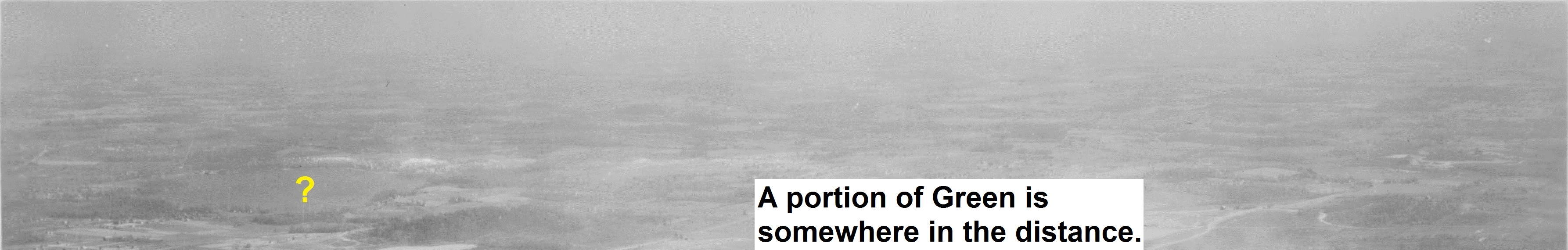
Who can tell us the name of the body of water at the yellow question mark in the old aerial photo
below? A portion of Green Township, Summit County, Ohio is somewhere in the distance.
The answer must include the direction (e.g. north (N), south (S), east (E), west (W),
NE, NW, SE, or SW) from the body of water to where the photo was taken.
For example, an acceptable, but incorrect, answer would be:
"The body of water is Grand Lake and the photo was taken NW of the lake
(i.e., or e.g., from Fort Wayne, Indiana)."
Clue #1:
More of the old aerial photo is shown below:
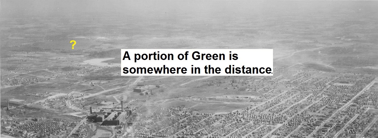
Clue #2:
Even more of the old aerial photo is shown below:
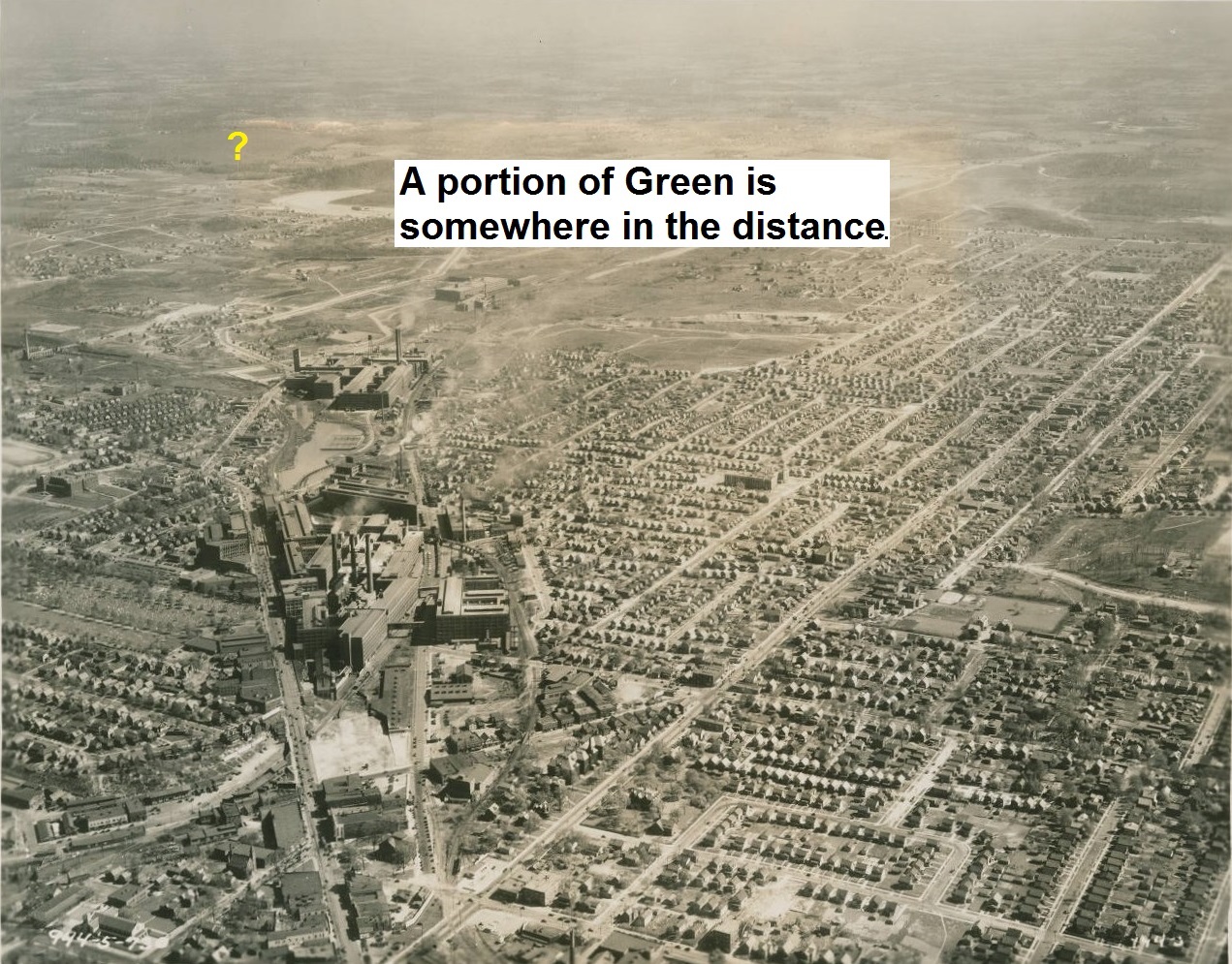
Clue #3:
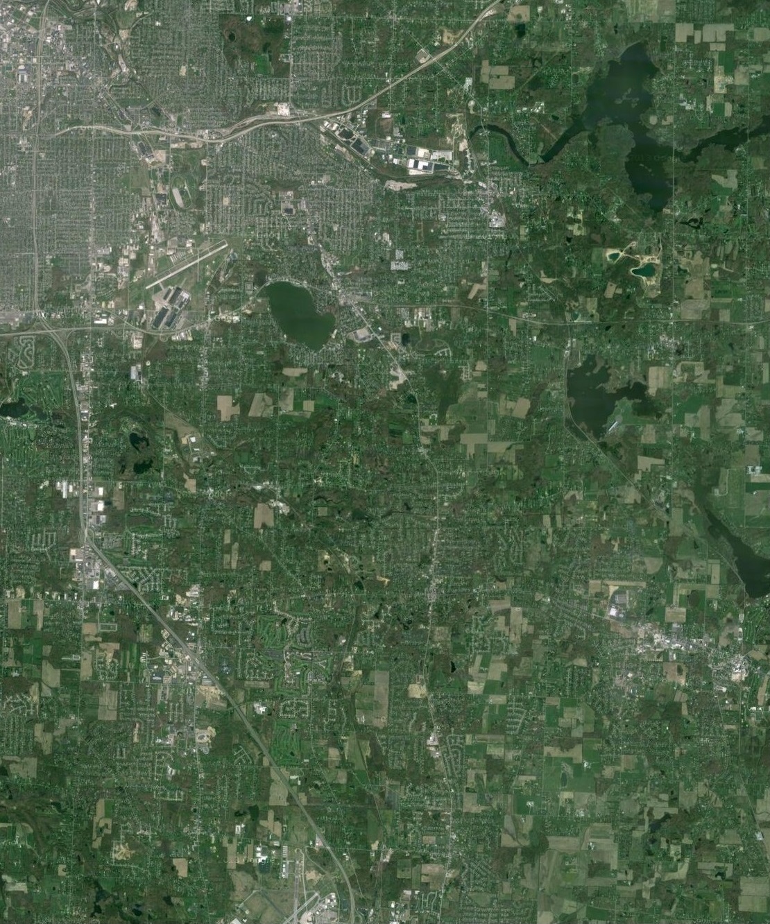
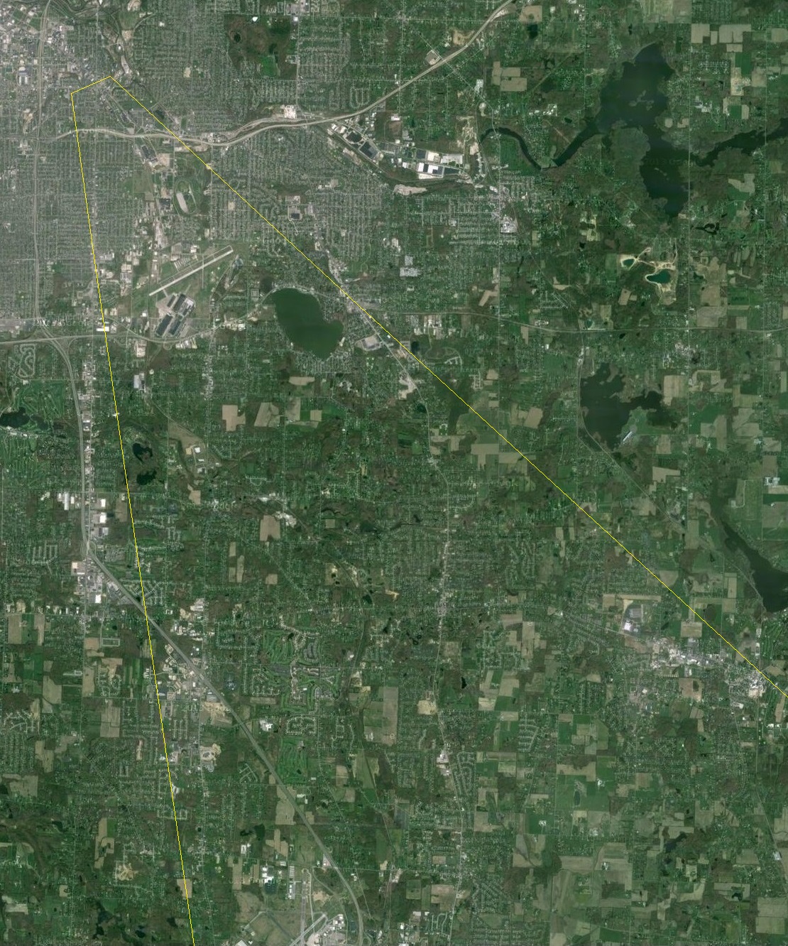
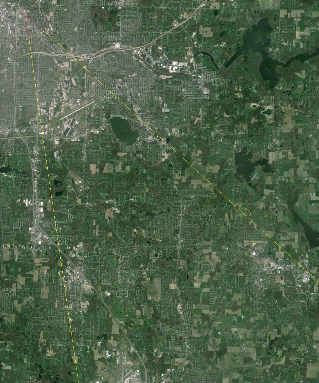
Much of the viewed area above is included in the recent aerial photo below:
Clue #4:
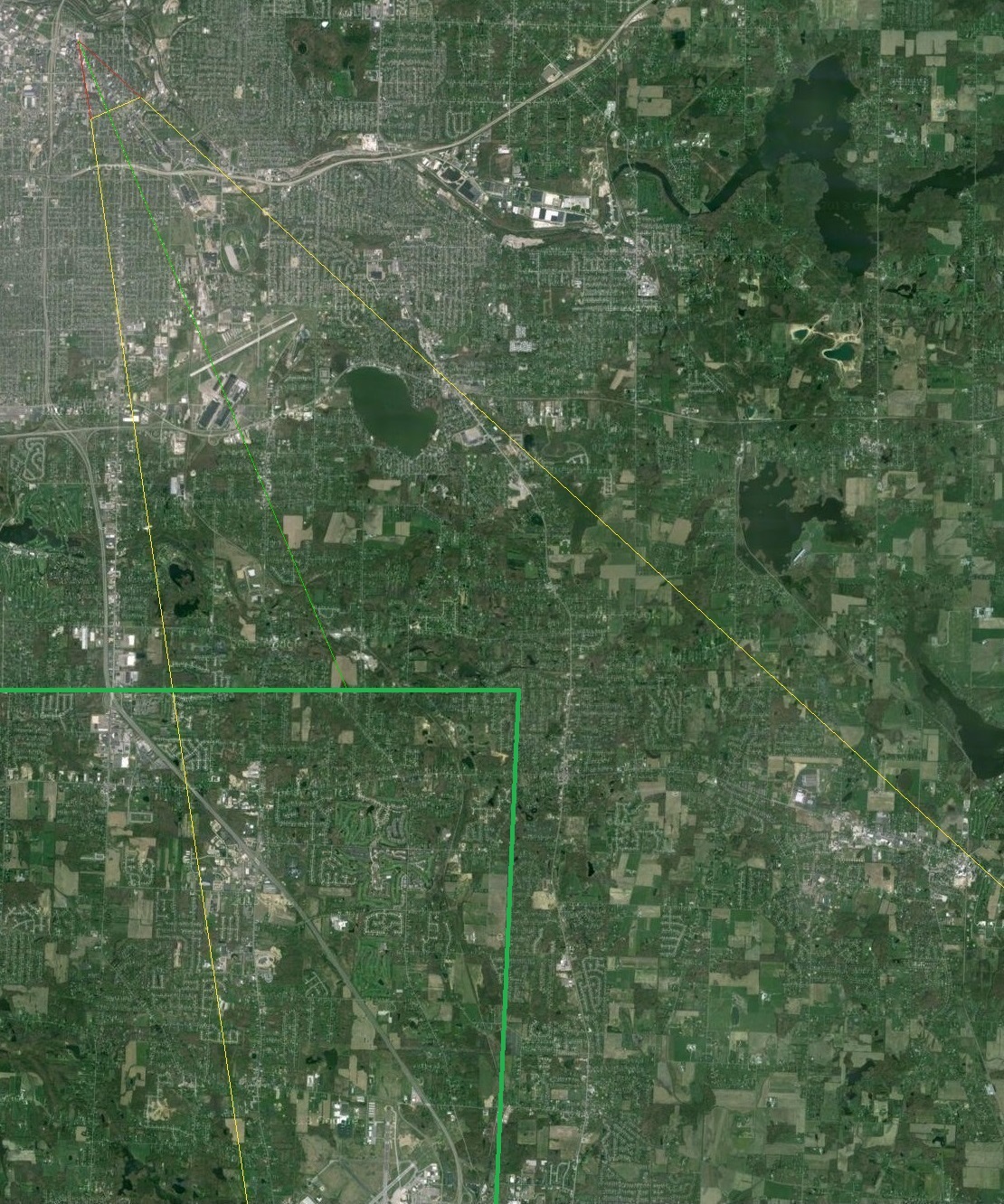
The area above is included below with yellow lines added to indicate the area viewed in the old
aerial photo:
Clue #5:
The complete unobstructed old aerial photo is shown below:
Clue #6:
The old aerial photo was taken in 1937 or 1938.
SOLUTION
The body of water is Springfield Lake in Springfield Township, Summit County, Ohio and the aerial
photograph was taken NW (northwest) of the lake.
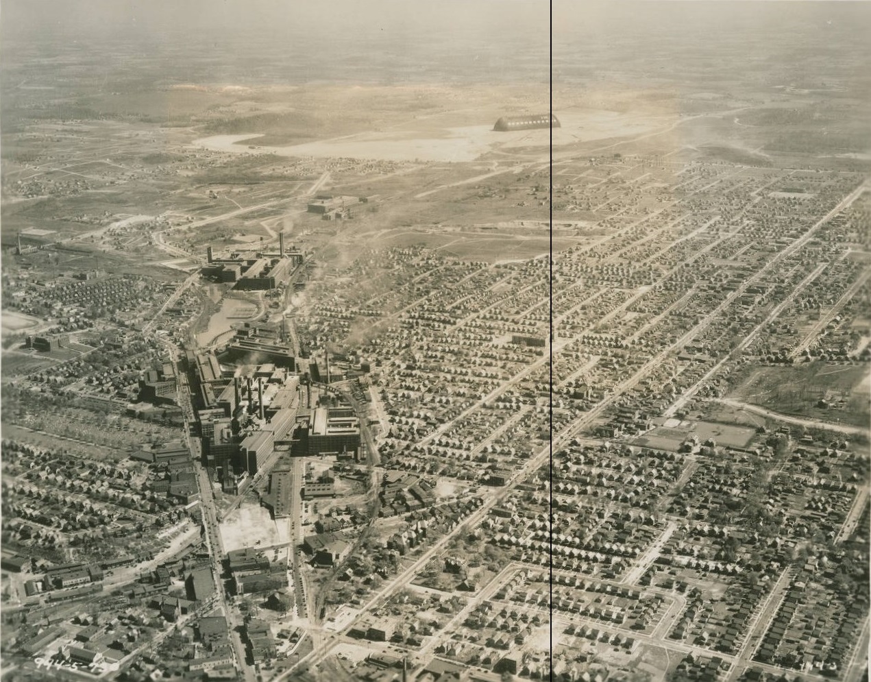
On the back of the photograph is written:
"District #5. 902 Municipal Bldg. Akron, Ohio. April 18, 1938. Code - E 30; Class - Cities;
Ident - Air view of East Akron, Goodyear Tire & Rubber Company plants #1, #2 and #3
and Zeppelin Hanger in the background."
The Goodyear Airdock, also known earlier as the Zeppelin Hanger, is located at 1210 Massillon Road
in Akron, Ohio. Specifically, at the south end point, it is located at: Latitude: N41Ḟ01'51.7", Longitude: W81Ḟ28'17.7", Elevation: 1,042 feet Mean Sea Level (MSL).
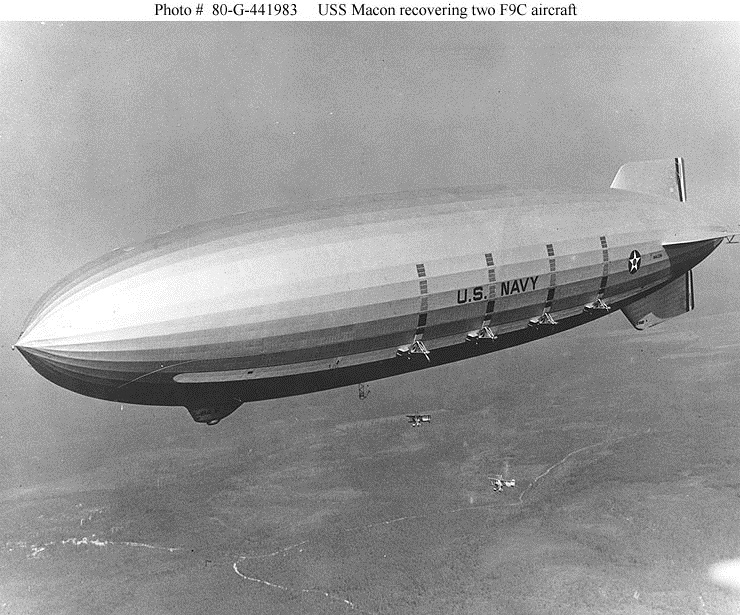
In 1929, the United States Navy commissioned the Goodyear Zeppelin Corporation to construct the
Airdock in which two lighter-than-air ships, later known as airships, dirigibles, and blimps, were
to be built: the United States Ship (USS) Zeppelin Rigid Scout (ZRS) named the USS Akron (ZRS-4)
and its sister ship, the USS Macon (ZRS-5).
The Airdock was constructed from April 20, 1929 to November 25, 1929 a cost of $2.2 million.
The maximum length of the Airdock is 1,175 feet, the maximum width is 325 feet, and the maximum
height is 211 feet. The semi-spherical doors at each end of the building are identical and weigh
600 tons each. The doors are fastened at the top by hollow 17 inch diameter forged pins that are
6 feet long. The doors rest on 40 wheels riding on curved railroad tracks. When it was constructed,
the Airdock was the largest building in the world without interior supports.
The USS Akron (ZRS-4) was first launched on August 8, 1931.
During a storm on April 4, 1933, the USS Akron crashed and sank into the Atlantic Ocean off the
coast of New Jersey. 73 of the 76 crew members lost their lives, mostly because they were not
issued, life jackets. Two crew members from the Navy non-rigid airship J-3 also lost their lives
after it crashed when sent out to rescue those on the USS Akron.
The USS Macon (ZRS-5) first launched on April 21, 1933, just a few weeks after the Akron crashed.
During a storm on February 12, 1935, the USS Macon crashed and sank into the Pacific Ocean off the
coast of California after the upper vertical fin failed. The weakness of the fin was identified
during an earlier incident and repairs to strengthen the structure were scheduled but not yet
performed at the time of the crash. Two of the 83 crew members lost their lives.
The Akron and Macon were 785 ft long, 20 feet shorter than the German commercial airship
Hindenburg, and were filled with helium instead of hydrogen as the Hindenburg.
The airships were often referred to as flying aircraft carriers because each ship carried Curtiss
F9C-2 Sparrowhawk biplanes that could be launched and recovered in flight, which extended the
range that the Akron and Macon could scout the open ocean for enemy vessels.
Discovery Video:
Note at minutes:seconds indicated:
13:49: Airdock construction
25:55: USS Akron crash
26:53: USS Macon design flaw in tail fins discovered
29:18: Engineer warns of danger but overruled by the Navy and only surviving officer of USS Akron
33:13: USS Macon crash due to known flaw
History of Airships Video:
Note at 25:21: USS Akron and Macon
PROOF THAT "A portion of Green is somewhere in the distance."
For those interested, proof that "A portion of Green is somewhere in the distance" follows:
There are no objects in Green Township that can be seen in the distance of the old aerial photo,
which could prove that "A portion of Green is somewhere in the distance". Therefore, we need to
prove this by other means. That will be to determine at approximately what position (i.e. latitude/
longitude location with altitude) the old aerial photo was taken to determine how far we can see to
the horizon (i.e. to or beyond Green).
Airdock Latitude/Longitude Location And Height
Using Google Maps, we can see that southern top point location of the Goodyear Airdock is at: Latitude: N41Ḟ01'51.7", Longitude: W81Ḟ28'17.7".
The known elevation at the Airdock is 1,042 feet.
We know that the maximum height of the Airdock is 211 feet.
Approximate Aircraft Latitude/Longitude Location
We can determine the approximate aircraft (i.e. airplane, airship, helicopter, hot air balloon,
etcetera) latitude/longitude location (i.e. point at Mean Sea Level (MSL) directly below the
aircraft) by extending the yellow lines, which were added to indicate the area viewed in the recent
aerial photo, backwards. We will assume that the camera was held approximately level, which would
have put the horizon in the vertical center of the photo, when the old aerial photo was taken.
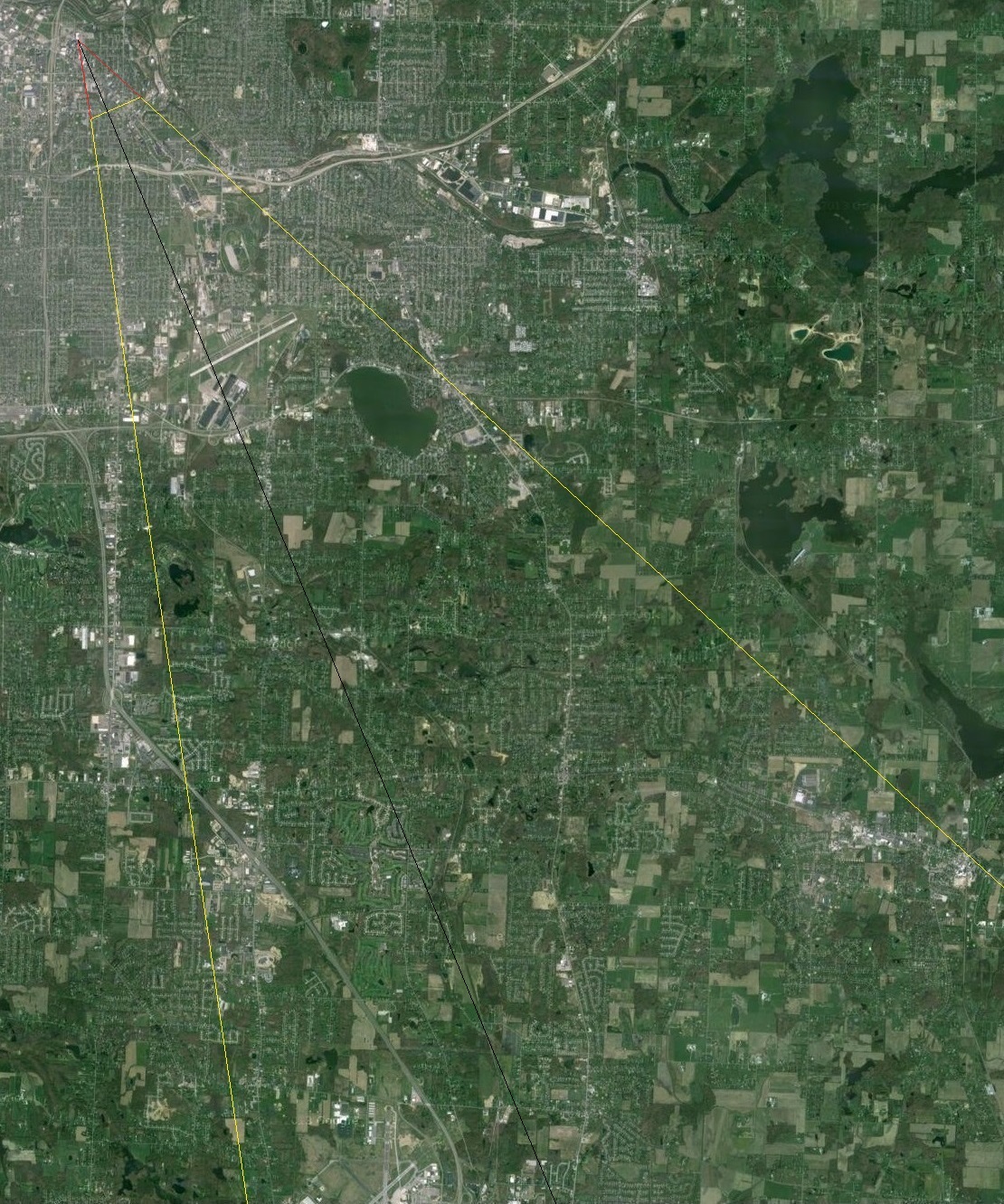
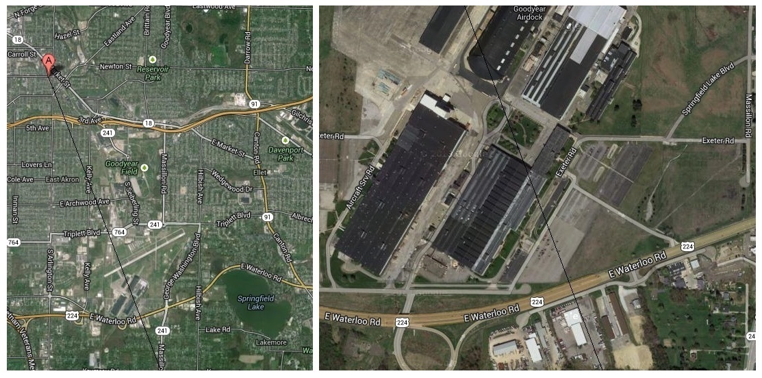
Where those lines meet identifies the approximate latitude/longitude location of the aircraft as
shown in the image below where the two red lines meet:
That point is at: Latitude N41Ḟ04'53.6", Longitude W81Ḟ29'57.1".
Line From Aircraft To Airdock And Beyond
We know that the vertical plane of a straight line along the ground from the aircraft latitude/
longitude location to the Airdock southern top point location would extend from the aircraft
location, past the bottom of the old aerial photo, and on to the Airdock southern top point location.
The image below is the previous image with a black line extending from the aircraft location to the
Airdock southern top point location and beyond:
That black line identifies the point at the bottom of the old aerial photo where that line extends
to and beyond the Airdock.
The photo below includes a black line from the bottom of the photo at the point identified
above that extends to the Airdock southern top point location and beyond:
We can see, after zooming into the photo, that the point on the ground that we can see on the other
side of the Airdock southern top point is just north (i.e. towards the Airdock) of Waterloo Road
(i.e. Route 224).
The recent aerial photos below include that line extending from the location at the bottom of the
photo to the Airdock southern top point and beyond Route 224:
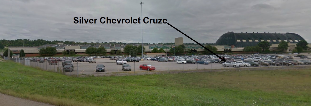
The Google Maps Car photo below shows the approximate location of that point, which is where the
silver Chevrolet Cruze is parked in the parking lot. The location of that point is at: Latitude N41Ḟ01'33.6", Longitude W81Ḟ28'08.7".
Notice that the ground at that location is approximately level with that at the Airdock as required
for our calculations to be valid.
If you were standing behind that car when the old aerial photo from 1937 or 1938 was taken, you
would be able to see the aircraft just above the southern top point of the Airdock.
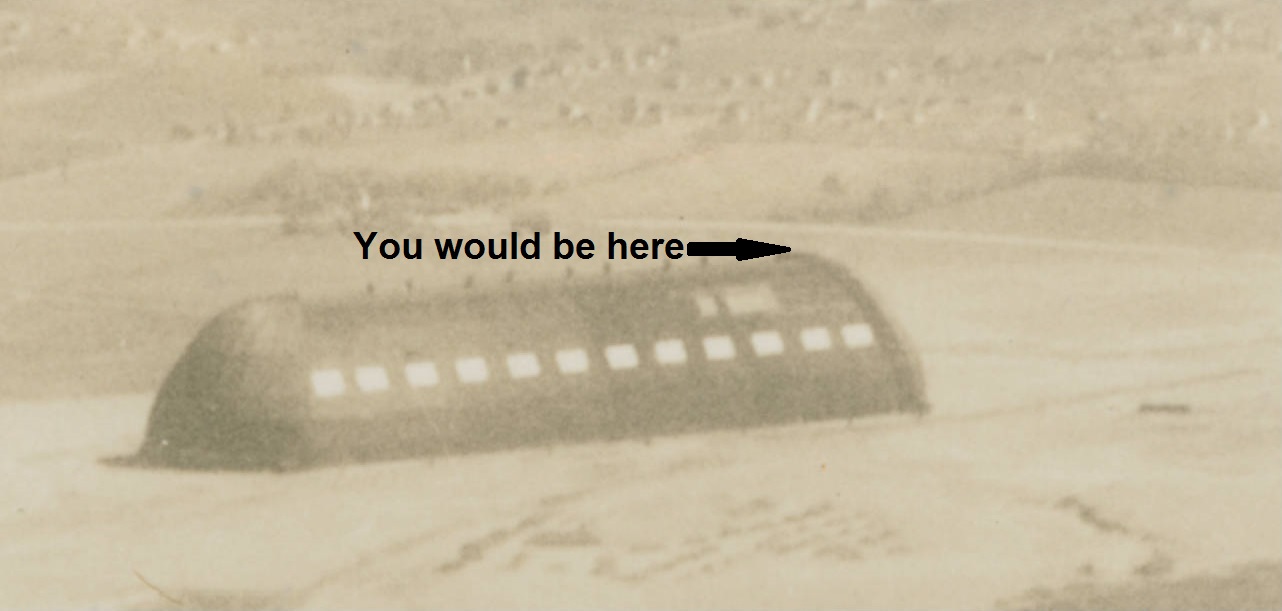
If you were standing on the roof of that car when that aerial photo was taken, you would be seen
in that photo at the southern top point of the Airdock and it would look as though you were
standing on the roof of the Airdock at the point shown below:
We can determine the angle from that point in the parking lot horizontally and up to the Airdock
southern top point. We can determine that angle from a photograph only or from the known height of
the Airdock and the latitude/longitude of those two points. Once we have that angle, we can then
determine the altitude of the aircraft to then determine if indeed that:
"A portion of Green is somewhere in the distance."
However, we should first determine if it is acceptable that we approximate the area in the aerial
photo to be flat instead of a portion of a sphere (actually an ellipsoid that bulges at the equator).
The effects of atmospheric refraction, which makes the actual distance observed to the horizon
greater than the distance calculated, will be ignored.
Since the elevation is relatively constant at approximately 1,000 feet above Mean Sea Level (MSL)
with a variance of about 150 feet to Green, elevation will be ignored.
Refer to
http://mygeoposition.com/
for elevations.
In the sections that follow, each step in the calculations is included so everyone can follow
along, rounding is performed (e.g. to the nearest foot) when appropriate, and all miles are in
statute (not nautical) miles.
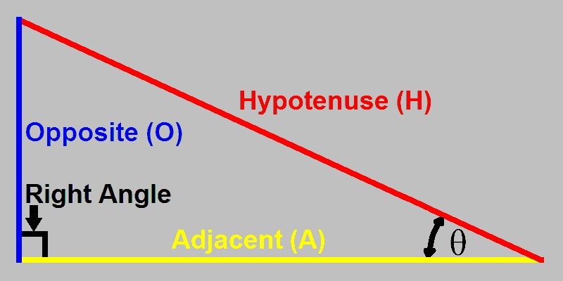
Right Triangle
Below is a right triangle with the three sides, right angle (90Ḟ) and angle theta (θ) identified:
The side Adjacent (A) to θ is the horizontal yellow line.
The side Opposite (O) to θ is the vertical blue line.
The Hypotenuse (H) is the side opposite to the 90 degree angle and is the red line.
Earth Curvature Rise Between Two Points
The Earth curvature rise between two points has virtually no impact on determining the altitude
of the aircraft when the old aerial photo was taken because the Airdock, which is located between
the aircraft and parking lot, is very close to the point in the parking lot as observed on the
other side of the Airdock from the aircraft. However, this rise is determined for curiosity,
clarity, and because it provides understanding in preparation for the next section.
We can use the Pythagorean Theorem to determine how much the curvature of the Earth rises between
two points on the Earth surface that are connected by a perfectly straight line that would cut slightly
through the surface of the Earth.
We know from the Pythagorean Theorem that, in a right triangle, the square of the hypotenuse is
equal to the sum of the squares of the other two sides. Therefore, we can determine how much the
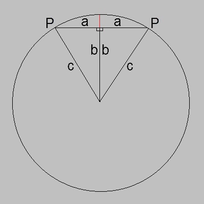
Earth rises between two points as shown in the graphic below, which includes a circle, two right
triangles, and the two points P. The circle is the surface of the Earth, 'c' is the radius of the
Earth, 'a' is one-half the distance between the two points, and 'b' is the radius of the Earth
minus the amount it rises between the two points as indicated by the red line.
Using the Pythagorean Equation and solving for 'b' gives:
(Note: √ = square root of quantity in parenthesis)
a² + b² = c²
b² = c² - a²
b = √(c² - a²)
Where:
a = half the distance between the two points
b = Earth radius minus rise in Earth between the two points
c = Earth radius (20,925,525 feet)
For 10 miles (i.e. 52,800 feet):
a = 52,800 / 2 = 26,400 feet
c = 20,925,525 feet
b = √(20,925,525² - 26,400²)
b = √(437,877,596,525,625 - 696,960,000)
b = √(437,876,899,565,625)
b = 20,925,508 feet
And:
b = Earth radius - rise
rise = Earth radius - b
rise = 20,925,525 - 20,925,508
rise = 16 feet
The results for various distances follow:
Distance
Rise
10 miles
16 feet
25 miles
104 feet
50 miles
416 feet
100 miles
1,665 feet
To verify the equation, the distance for half way around the planet would be:
20,925,525 x 2 / 5280 = 7,926 miles
for a rise of 20,925,525 feet which is the radius of the planet as expected and is correct.
Earth Curvature Arc Distance Versus Straight Line Distance Between Two Points
The Earth curvature arc distance between two points is different from the straight line distance.
We should determine if there is a significance in the difference of the distance between the
aircraft latitude/longitude location point (i.e. at MSL on the Earth) and the point in the parking
lot location when connected by the Earth curvature arc versus a straight line.
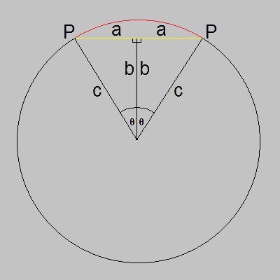
The graphic below consists of the graphic above with the angles theta (θ) included and the curved
arc distance indicated by the red arc and the straight line distance indicated by the yellow line:
We know that the distance (length) of the circumference of a circle is radius x Pi (Π) and Pi
has a value of about 3.1415926536.
We also know that sine(θ) = Opposite(O)/Hypotenuse(H) and solving for θ gives:
θ = arcsine(O/H)
In the graphic above, a = O and c = H.
Where:
a = half the distance between the two points
c = Earth radius (20,925,525 feet)
θ = arcsine(distance / 2 / Earth radius)
Note that θ is then multiplied by 2 for both right triangle angles.
For 10 miles (i.e. 52,800 feet):
θ = arcsine(52,800 / 2 / 20,925,525) x 2
θ = 0.0025232349 radians or 0.1445707078 degrees
The arc distance (length) is θ (in radians) x Earth radius for:
arc distance = 0.0025232349 x 20,925,525
arc distance = 52,800.015 feet
The difference in the distance is:
difference = arc distance - straight distance
difference = 52,800.015 - 52,800
difference = 0.085 feet
difference = about 1 inch
The results for various distances follow:
Distance
Difference
10 miles
0.085 feet
25 miles
0.219 feet
50 miles
1.751 feet
100 miles
14.008 feet
To verify the equation, the distance for half way around the planet would be:
20,925,525 x 2 / 5,280 = 7,926 miles
θ = arcsine(7,926 x 5,280 / 2 / 20,925,525) x 2 = 3.1415926536
3.1415926536 x 20,925,525 = 65,739,476 feet
for a difference of 65,739,476 - 41,851,050 = 23,888,426 feet which is 4,524.323 miles, and is
expected and correct because that total arc distance of 65,739,476 feet is indeed half of the
circumference as diameter x Π / 2 as:
20,925,525 x 2 x 3.1415926536 / 2 = 65,739,476 feet or 12,450.658 miles
and twice that is indeed the circumference of the Earth in miles as in 24,901 miles.
Distance To Horizon For Given Altitude
There are two distances to the horizon that can be considered for a specified altitude.
One is the distance from the latitude/longitude location point (i.e. MSL on the Earth beneath
the altitude point) over the Earth curvature arc to the point on the horizon. The other is the
distance from the altitude point directly (i.e. through the air) to the point on the horizon.
We should determine if there is a significance in the difference of the distance between the
aircraft latitude/longitude location point (i.e. MSL on Earth surface) over the Earth curvature arc
to the point on the horizon versus the distance from the aircraft location altitude point to the
point on the horizon.
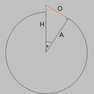
The graphic below includes a circle and a right triangle. The circle is the surface of the Earth,
'A' is Adjacent to the angle θ, 'O' is Opposite to the angle θ and is the line of sight to
the horizon, and 'H' is the Hypotenuse and is the radius of the Earth plus the altitude, which is
indicated by the blue line.
Surface To Horizon Distance (Yellow Arc):
We know that cosine(θ) = A/H and solving for θ gives:
θ = arccosine(A/H)
Where:
A = Earth radius (20,925,525 feet)
H = Earth radius + altitude
θ = arccosine(Earth radius / (Earth radius + altitude)
The arc distance (length) is θ (in radians) x Earth radius for:
arc distance = Earth radius x arccosine(Earth radius / (Earth radius + altitude))
For an altitude of 1,000 feet:
arc distance = 20,925,525 x arccosine(20,925,525 / (20,925,525 + 1,000))
arc distance = 20,925,525 x arccosine(20,925,525 / 20,926,525)
arc distance = 20,925,525 x arccosine(0.9999522138)
arc distance = 20,925,525 x 0.0097761570
arc distance = 204,571.218 feet
arc distance in miles = 204,571.218 / 5,280 = 38.744549 miles
Altitude To Horizon Distance (Red Line):
Using the Pythagorean Equation and solving for 'O' gives:
A² + O² = H²
O² = H² - A²
O = √(H² - A²)
Where:
A = Earth radius (20,925,525 feet)
H = Earth radius + altitude
O = √((Earth radius + altitude)² - Earth radius²)
For an altitude of 1,000 feet:
O = √((20,925,525 + 1,000)² - 20,925,525²)
O = √(20,926,525² - 20,925,525²)
O = √(437,919,448,575,625 - 437,877,596,525,625)
O = √(41,852,050,000)
O = straight distance = 204,577.736 feet
straight distance in miles = 204,577.736 / 5,280 = 38.745783 miles
The surface to horizon and altitude to horizon distances and differences for various altitudes
follow:
Altitude
Surface To Horizon
Altitude To Horizon
Difference
100 feet
12.252322 miles
12.252361 miles
0.206104 feet
500 feet
27.396806 miles
27.397242 miles
2.304284 feet
1,000 feet
38.744549 miles
38.745783 miles
6.517428 feet
2,000 feet
54.791976 miles
54.795467 miles
18.433673 feet
3,000 feet
67.104855 miles
67.111269 miles
33.864091 feet
4,000 feet
77.484470 miles
77.494344 miles
52.136058 feet
Determine Angle
As mentioned previously, we can determine the angle from the point in the parking lot horizontally
and up to the Airdock southern top point. We can do so from a photograph only or from the known
height of the Airdock and the latitude/longitude of those two points.
Angle From Photograph:
The most accurate location to take the photograph from, known as the "vantage point", would be at
a point that is far from and equal distance from the vertex of the angle (i.e. point in the parking
lot), the Airdock southern top point, and the location on the ground directly beneath the Airdock
southern top point. The photograph must include all three of those points or include points from
which those points can be determined precisely in the photograph. After examining all possibilities
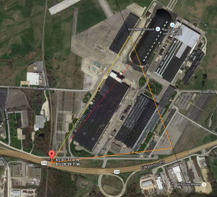
available from the available Google Maps Car photos, the vantage point chosen is as shown at the
marker towards the lower left corner in the photo below:
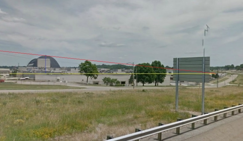
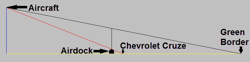
The photo taken by the Google Maps Car at that vantage point is given below and includes the right
triangle produced which consists of the Hypotenuse (red diagonal line), side Adjacent to the angle
(yellow horizontal line), and side Opposite to the angle (blue vertical line). Note that the point
on the left end of the yellow line is precisely at the same level as the base of the Airdock as
shown by aerial photo above.
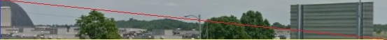
The image below consists of only the right angle depicted in the photo above. This image is 553
pixels wide and 58 pixels high:
We know that tangent(θ) = O/A and solving for θ gives:
θ = arctangent(O/A)
Where:
O = 58 pixels
A = 553 pixels
For:
θ = arctangent(58 / 553)
θ = arctangent(0.1048824593) θ = 5.9874317217 degrees
Angle From Latitude/Longitude Of Two Points And Height:
We determined that the latitude/longitude of the point in the parking lot is at: N41Ḟ01'33.6" W81Ḟ28'08.7".
and the Airdock southern top point is at: N41Ḟ01'51.7" W81Ḟ28'17.7".
We know that tangent(θ) = O/A and solving for θ gives:
θ = arctangent(O/A)
Where:
O = 211 feet
A = distance from point in parking lot N41Ḟ01'33.6" W81Ḟ28'08.7" and Airdock N41Ḟ01'51.7" W81Ḟ28'17.7"
A = 1958.88 feet (by
GPS Visualizer)
For:
θ = arctangent(211 / 1958.88)
θ = arctangent(0.1077146124) θ = 6.1478889726 degrees
Angle From Photograph result is: 5.9874317217 degrees
Angle From Latitude/Longitude Of Two Points And Height result is: 6.1478889726 degrees
The difference between those two results is:
6.1478889726 - 5.9874317217 = 0.1604572509 degree
which is only 2.6 percent difference.
Rounding to 6 degrees makes the difference even less.
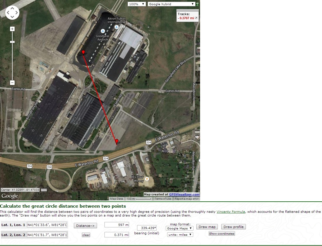
CAUTION: Some Great Circle calculators give different results.
For example,
GPS Visualizer
gives the following map with a distance of 0.371 miles for 1,958.88 feet:
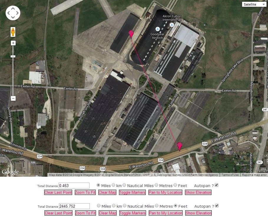
However,
Draft Logic
gives the following map with a distance of 0.463 miles for 2,445.752 feet:
Aircraft Altitude
The distance from that approximate aircraft latitude/longitude location to the point in the parking
lot is 4.144 miles or 21,880.32 feet.
We know that tangent(θ) = O/A and solving for O gives:
O = tangent(θ) x A
Where:
θ = 6 degrees
A = 21,880.32 feet
For:
O = tangent(6 degrees) x 21,880.32
O = 0.1051042353 x 21,880.32
O = 2,299.714
O = about 2,300 feet
Distance To Horizon
Our earlier results for an altitude of 2,000 feet was 54.791976 miles (surface to horizon) from:
arc distance = Earth radius x arccosine(Earth radius / (Earth radius + altitude))
For an altitude of 2,300 feet:
arc distance = 20,925,525 x arccosine(20,925,525 / (20,925,525 + 2,300))
arc distance = 20,925,525 x arccosine(20,925,525 / 20,927,825)
arc distance = 20,925,525 x arccosine(0.9998900985)
arc distance = 20,925,525 x 0.0148258925
arc distance = 310,239.5834837898 feet
arc distance in miles = 310,239.5834837898 / 5280 = 58.757497 miles
The distance from the aircraft, at 2,300 feet, that can be seen to the horizon (over the surface)
is about 59 miles.
Horizon Points
The aircraft is located at N41Ḟ04'53.6" W81Ḟ29'57.1".
At the altitude of 2,300 feet, the horizon is 59 miles from the aircraft. GPS Visualizer was used for the calculations that follow:
The bearing from the aircraft to the point in parking lot at N41Ḟ01'33.6" W81Ḟ28'08.7" is: 157.759Ḟ (distance = 4.144 miles).
The location 59 miles from the aircraft at a bearing of 157.759Ḟ is: Latitude: N40Ḟ17'23.199", Longitude: W81Ḟ04'30.52".
Degrees: 40.28977761947, -81.0751443202.
Northwest of Cadiz, Ohio.
The bearing from the aircraft to the point at the left edge of the photo at N41Ḟ01'58.0" W81Ḟ25'44.4" is: 132.639Ḟ (distance = 4.977 miles).
The location 59 miles from the aircraft at a bearing of 132.639Ḟ is: Latitude: N40Ḟ30'02.22", Longitude: W80Ḟ40'25.386".
Degrees: 40.50061657433, -80.67371838248.
Northwest of Toronto, Ohio.
The bearing from the aircraft to the point at the right edge of the photo at N41Ḟ02'29.1" W81Ḟ29'28.4" is: 171.48Ḟ (distance = 2.801 miles).
The location 59 miles from the aircraft at a bearing of 171.48Ḟ is: Latitude: N40Ḟ14'09.208", Longitude: W81Ḟ19'59.757".
Degrees: 40.2358910889, -81.33326580187.
Northeast of Salt Fork Lake.
Green Border Point
It appears that the old aerial photo may not include the horizon; therefore, we do not know
absolutely, positively, without a doubt, with complete confidence and certainty that:
"A portion of Green is somewhere in the distance".
There are no objects in Green that can be seen in the distance which could indicate if indeed that:
"A portion of Green is somewhere in the distance".
However, we can determine the approximate point of the Green border in that photo by once again
using the 211 feet high Airdock and it's location.
The bearing from the aircraft to the point in parking lot is: 157.759Ḟ
The point on the Green border that is directly on the line that extends from the aircraft location
to the point in the parking lot and beyond is at: Latitude: N40Ḟ59'18.1", Longitude: W81Ḟ27'50.9".
which is 6.955 mi miles from the approximate latitude/longitude of the aircraft and is shown by
the narrow green line that extends from the aircraft to the Green border shown by a wide green line
as added to the aerial photo below:
It may be worthy to note the following:
The Welcome To Green sign on Massillon Road (i.e. Route 241) is at: Latitude: N40Ḟ59'18.1", Longitude: W81Ḟ27'50.9".
which is 6.687 miles from the approximate latitude/longitude of the aircraft.
The Welcome To Green sign on Pickle Road is at: Latitude: N40Ḟ59'13.1", Longitude: W81Ḟ28'25.4".
which is 6.661 miles from the approximate latitude/longitude of the aircraft.
Angle To Green Border Point
Note the graphic below in which we simply need to solve for the length of the vertical black line
to determine if the point in Green can be seen:
We know the aircraft altitude is 2,300 feet and the distance to the Green border is 6.955 miles.
Therefore, we can determine the angle of the diagonal black line at the Green border to the
aircraft and then the height of the vertical black line at the Airdock.
Angle Of Diagonal Black Line At Green Border To Aircraft:
tangent(θ) = O/A
θ = arctangent(O/A)
Where:
O = 2,300
A = 36,933.6 (6.995 x 5,280)
For:
θ = arctangent(2,300 / 36,933.6)
θ = arctangent(0.0622739186)
θ = 3.5634310863 degrees
Length Of Vertical Black Line At Airdock:
The distance from the Airdock to the Green border is 3.182 miles = 16,800.96 feet.
Therefore, the height of the vertical black line is:
tangent(θ) = O/A
O = tangent(θ) x A
For:
O = tangent(3.563) x 16,800.96
O = 0.0622739186 x 16,800.96
O = 1046.2616154396
This height is equal to the height of
1,046 / 211 = 4.9585858552 Airdocks
or about 5 Airdocks.
Therefore, we can stack 4 more Airdock southern portions on top of that in the aerial photo to
acquire the required 1,046 feet as shown below:
The point that can be seen just over the top of the top Airdock is the Green border point.
Therefore, we can conclude that indeed: "A portion of Green is somewhere in the distance".
OTHER OBSERVATIONS
For those interested, important latitude/longitude locations with elevations are identified below:
Point
Latitude
Longitude
Elevation
Photo Bottom Center
N41Ḟ04'15.4"
W81Ḟ29'31.0"
1,025 feet
Photo Bottom Left
N41Ḟ04'22.5"
W81Ḟ29'15.3"
1,009 feet
Photo Bottom Right
N41Ḟ04'12.0"
W81Ḟ29'47.3"
1,054 feet
Photo Left Edge
N41Ḟ01'58.0"
W81Ḟ25'44.4"
1,092 feet
Photo Right Edge
N41Ḟ02'29.1"
W81Ḟ29'28.4"
1,134 feet
Aircraft
N41Ḟ04'53.6"
W81Ḟ29'57.1"
1,041 feet
Airdock South Top Point
N41Ḟ01'51.7"
W81Ḟ28'17.7"
1,042 feet
Point in Parking Lot
N41Ḟ01'33.6"
W81Ḟ28'08.7"
1,071 to 1,085 feet
Green Border Point
N40Ḟ59'18.4"
W81Ḟ26'53.7"
1,083 feet
Green Sign on 241
N40Ḟ59'18.1"
W81Ḟ27'50.9"
1,111 feet
Green Sign on Pickle Road
N40Ḟ59'13.1"
W81Ḟ28'25.4"
1,151 feet
Green Border Closest Right
N40Ḟ59'18.7"
W81Ḟ28'44.0"
1,134 feet
Green Northwest Corner
N40Ḟ59'17.7"
W81Ḟ31'54.4"
1,092 feet
Green Northeast Corner
N40Ḟ59'18.5"
W81Ḟ24'58.3"
1,108 feet
Green Southeast Corner
N40Ḟ54'23.4"
W81Ḟ25'12.7"
1,119 feet
Green Southwest Corner
N40Ḟ54'37.1"
W81Ḟ32'11.2"
1,040 feet
Horizon: NW Cadiz, Ohio
N40Ḟ17'23.199"
W81Ḟ04'30.52"
928 feet
Horizon: NW Toronto, Ohio
N40Ḟ30'02.22"
W80Ḟ40'25.386"
1,222 feet
Horizon: NE Salt Fork Lake
N40Ḟ14'09.208"
W81Ḟ19'59.757"
1,122 feet
The points below are included in the Google Maps image to follow with markers and lines connected
as appropriate:
Horizon (NE Salt Fork Lake): N40Ḟ14'09.208" W81Ḟ19'59.757" (40.2358910889 -81.33326580187)
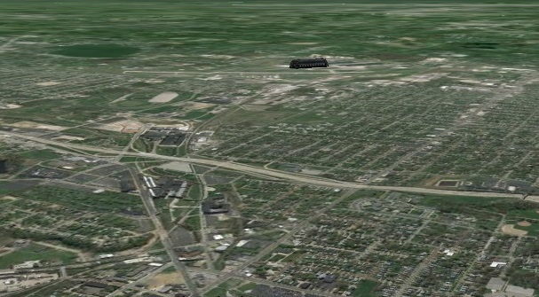
The image below is of the area in recent years as acquired from Google Earth at approximately the
same position that the aircraft was when the old aerial photo was taken in 1937 or 1938.
The top of the image is at the horizon.
The old aerial photo and the Google Earth image above may be compared by using the CHANGE button
below. Apparently, a wide angle lens was used when the old aerial photo was taken which would
account for the different widths.