WELCOME to THE GREEN HISTORY DETECTIVES
Episode 47
The buttons above images are identified and described below:
BUTTON
DESCRIPTION
<<BACK
Go Back to the previous image in the set
NEXT>>
Go to the Next image in the set
ZOOM IN
Zoom into image
NORMAL
Restore image to initial size
ZOOM OUT
Zoom out of image
Repeating an operation is most effectively performed by clicking
on a button and then pressing the enter key repeatedly as desired.
Panning is most effectively performed by using the cursor keys.
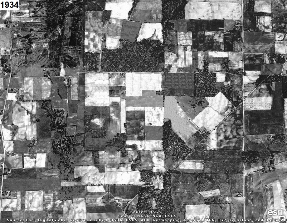
Who can tell us what is now located where the aerial photograph(s) below were taken?
The year that each aerial photo was taken is given in the upper left corner of the photo.
The clues will consist of adding another aerial photo of a later year to the set.
ADDITIONAL CLUE:
East is up (i.e. North is left) in the aerial photos above.
On October 5, 1942, after the Japanese attacked Pearl Harbor on December 7, 1941, the Civil
Aeronautics Administration (CAA) approved $2 million to construct an airport in or near Canton, Ohio.
In December 1942, Canton City Council approved to purchase a site for the new airport.
In 1943, Stark and Summit County Commissioners and Chamber of Commerce representatives agreed to
work together on a jointly sponsored CAA airport.
On April 27, 1943, the commissioners announced the new airport name as: 'The Canton-Akron Memorial
Airport' to honor veterans of the two world wars.
Notice the gross lack of concern for public safety, for profit, by Akron City and Akron Municipal
Airport officials as described below and documented on the
Akron-Canton Airport History
page:
In February 1946, eight months prior to the airport's dedication, American, Eastern, Capital, and
United announced their plans to move from Akron Municipal Airport to Canton-Akron Memorial Airport.
Outraged, Akron City and airport officials claimed that the airlines would be violating their lease
agreements if they moved. The airlines argued that the natural bowl in which the Akron Municipal
Airport was located (with the Goodyear Zeppelin dock on one side and Derby Downs on the other),
foggy conditions, and short runways created hazardous conditions for commercial pilots. City
officials also protested that travel cost would increase significantly if the airlines moved south.
To help alleviate the tension, the Airport was renamed the Akron-Canton-Massillon Airport. Later,
Massillon was dropped from the name and replaced by "regional", representing the many communities
that helped develop the airport over the years. Akron-Canton Regional Airport is currently the
airfield's official name although for advertising and communication purposes, the terminal is
referred to as Akron-Canton Airport.
Akron Municipal Airport lost its fight to hold the four airlines in October 1947 when the CAA
recommended that they be transferred to Akron-Canton Airport. Akron Municipal though, continued
to fight the move, offering a huge terminal expansion and extension or their runways to 5,340 and
5,400 feet. It was not until March 9, 1948, that the Civil Aeronautics Board allowed the four
airlines to move to the new Airport.
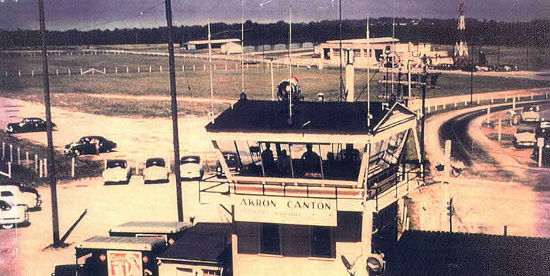
The airport was dedicated on October 13, 1946, as the Akron–Canton–Massillon Airport. However, the
name was later changed to the Akron–Canton Regional Airport. Passenger air service began in 1948
when American, United, Capital, and Eastern airlines moved from the Akron Fulton International
Airport. A permanent terminal was built in 1955 and was expanded in 1962.
The table below identifies the aircraft crashes that have occurred so far at the Akron-Canton
Airport due to accident, negligence, or incompetence and includes links to additional information
for each occurrence:
The airport Federal Aviation Administration (FAA) and International Air Transport Association (IATA)
identifier is CAK and the International Civil Aviation Organization (ICAO) identifier is KCAK.
The airport elevation is 1,225.5 feet, and the magnetic variation is W07.
There are two physical runways that are both made of asphalt and are 150 feet wide.
Runway 5/23 is 8,204 feet long and Runway 1/19 is 7,601 feet long.
The aerial photo below includes a white rectangle to identify the area in the aerial photos above.