SOLUTION
The area in the aerial photographs is of what was commonly referred to as: The Strip Mines on
Wise Road.
However, the site is officially identified by the United States (U.S.) Environmental Protection
Agency (EPA) and the U.S. General Accounting Office (GAO) as:
WISE ROAD DISPOSAL SITE
Green Township, Summit County, Ohio
U.S. EPA ID: OH0001328350
U.S. GAO ID: 2183-A
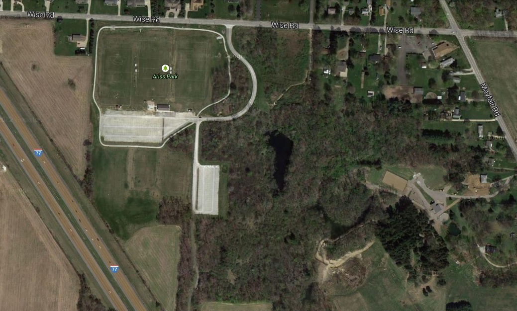
The aerial photo below includes a white rectangle to identify the area in the aerial photos above,
a red polygon to identify the WISE ROAD DISPOSAL SITE, and a green rectangle, which can be seen
when zoomed out, to identify Green Township:
NOTE:
The red polygon northeast and out of the green rectangle (i.e. out of Green Township) identifies the
Industrial Excess Landfill (IEL), Superfund Site, Uniontown, Ohio, U.S. EPA ID: OHD000377911
(in Stark County) as investigated, explained, and explored in the SOLUTION for Episode 5.
That Uniontown toxic waste landfill has been called the third worst Superfund Site in the entire nation.
That IEL Superfund Site is located less than 4 miles from the WISE ROAD DISPOSAL SITE and both
sites served as waste dumps for Akron rubber companies.
The main objective of this Episode is to inform the community about historic disposal practices at
the WISE ROAD DISPOSAL SITE which have evidently resulted in soil, sediment, and groundwater
contamination causing an environmental hazard to the adjacent community and surrounding environment.
FOIA Request For WISE ROAD DISPOSAL SITE Documents
The U.S. EPA WISE ROAD DISPOSAL SITE documents were acquired by utilizing the Freedom Of
Information Act (FOIA) law, which gives citizens the right to access information from the federal
government. It is often described as the law that keeps citizens in the know about their government.
The request sent to
EPA Region 5
follows. Note that the Zoom and Pan feature were not included in
that message but are provided for visitors of this web page.
Subject: Wise Road Disposal EPA Site #OH0001328350
Date: 3/19/2014 12:36:04 P.M. Eastern Daylight Time
From: TDBConsulting@aol.com
To: r5foia@epa.gov
Hello:
I would like to know where I can find information about the Wise Road Disposal EPA Site
#OH0001328350 which is located on Wise Road in Green Township (Summit County) near
Greensburg, Ohio, zip code 44232. I would like to know when it was opened and closed and
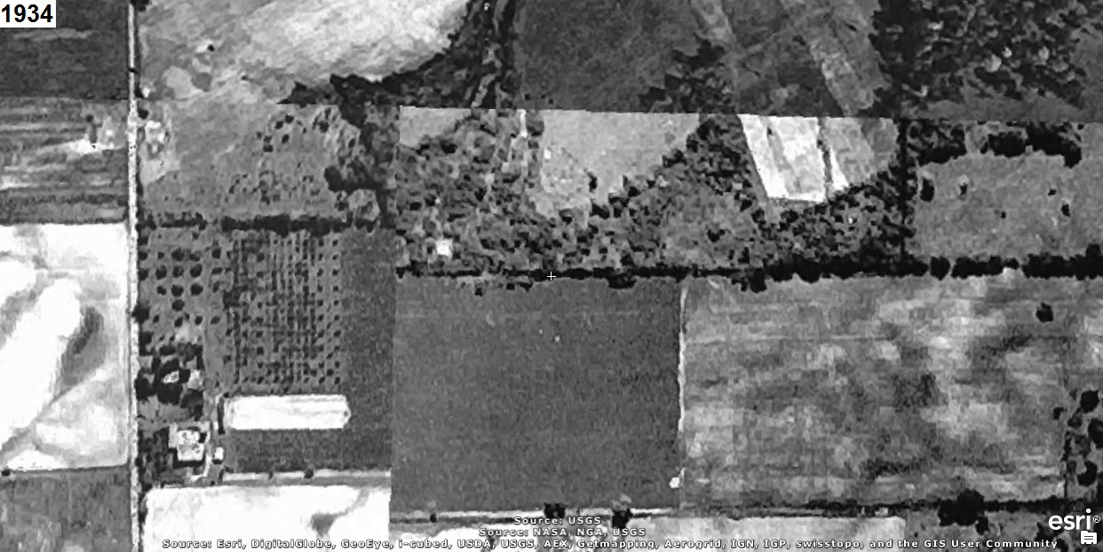
what type of material was removed or deposited there. The aerial photos below are of the
area and are oriented with north to the left (i.e. east is up).
The 1934 aerial photo below shows the area before material was removed or deposited.
Note that no bodies of water exist:
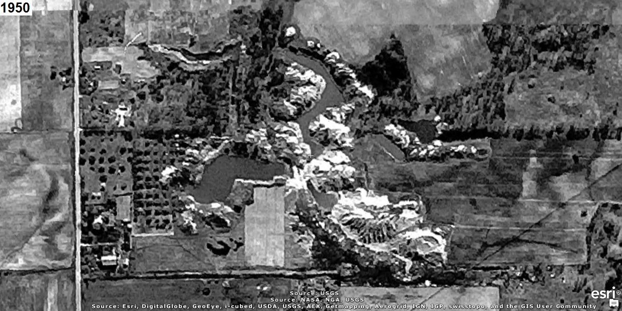
The 1950 aerial photo below shows the area during excavation which caused the bodies of
water to form:
The 1980 aerial photo below shows the area after the site closed and that the bodies of
water still exist:
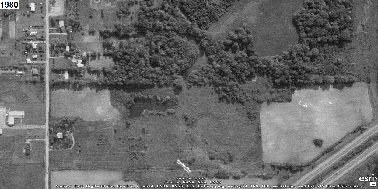
The bodies of water in the aerial photos above suggest that material was only removed and
not deposited there.
I would like to know what material was removed (i.e. stripped) from the land and caused
those bodies of water to form. I would also like to know if material was indeed deposited
there and what that material was.
I would like the results in an electronic file.
Thank you for your time and efforts,
Tim Ball
Email: TDBConsulting@aol.com
|
The WISE ROAD DISPOSAL SITE documents are now available in the files provided at:
FOIA Online
(Tracking Number: EPA-R5-2014-004750).
WISE ROAD DISPOSAL SITE Documents
The files that pertain to the WISE ROAD DISPOSAL SITE are listed below:
05-427341.pdf dated 12/2/1997:
GAO SURVEY OF NPL-ELIGIBLE SITES - STATES, TERRITORIES & TRIBES - WISE ROAD DISPOSAL
05-427342.pdf dated 1997:
GAO SURVEY OF NPL-ELIGIBLE SITES - USEPA - WISE ROAD DISPOSAL
05-427353.pdf dated 9/7/1995:
EPA INTER-OFFICE MEMO RE: MS REFERRAL FOR WISE ROAD DISPOSAL SITE W/ATTACHED
MASTER LIST REFERRAL & MAP
05-427354.pdf dated 9/30/1996:
EPA - REGION V RISE INFORMATION FORM
05-427358.pdf dated 9/18/1995:
INTEGRATED ASSESSMENT (IA) REPORT W/ ATTACHED LETTER
tim.ball.pdf dated 3/19/2014:
REQUEST FOR INFORMATION: Wise Road Disposal EPA Site #OH0001328350
NOTE:
NPL = National Priorities List
WISE ROAD DISPOSAL SITE Document Information
The EPA Inter-Office Communication, dated September 7, 1995 in the file 05-427353.pdf, states that:
The Wise road disposal site was first discovered in 1990 by NEDO/DERR. The property was used
for coal mining prior to 1940 when the Industrial Disposal Company began using the location for
waste disposal. In 1951 the property was sold to John S. Ariss and Agatha Ariss. Our files indicate
that disposal activity may have continued into the 1950's. All residents in the area rely on private
wells. This site has been selected for investigation under our Cooperative Agreement with USEPA.
Please assign this site an Ohio I.D. number.
|
NOTE:
NEDO = Northeast District Office
DERR = Division of Emergency and Remedial Response
The EPA Integrated Assessment Report for Wise Road Disposal Site, dated September 30, 1996,
is included in the file 05-427358.pdf. Important portions from that document follow:
Section 1.0 EXECUTIVE SUMMARY (note the bolded text):
1.0 EXECUTIVE SUMMARY
On April 16-17, 1996, Site Investigation Field Unit (SIFU), and Northeast District Office personnel
of the Ohio Environmental Protection Agency (OEPA) Division of Emergency and Remedial
Response (DERR) conducted a Integrated Assessment (IA) at the Wise Road Disposal site in Green
Township, Summit County, Ohio. The main objective of this IA was to determine if previous
operations and historic disposal practices at this facility resulted in soil, sediment and/or extensive
groundwater contamination which would potentially cause an environmental hazard to the adjacent
community and surrounding environment.
Work conducted during the IA included: 16 samples as a part of this investigation and they were
collected from four separate environmental media that included, five groundwater, five soil, three
sediment, and three surface water at or near the Wise Road Disposal site during this investigation.
The number indicated does not include duplicates, replicates, background, and/or trip blanks that
may have been collected as a result of this investigation for QA/QC purposes. All of the samples
that were collected as a result of this activity were submitted to CLP laboratories, and analyzed for
TCL organics (volatiles, semi-volatiles, pesticides and PCB's) and TAL metals.
A number of different contaminants were detected from those samples collected and analyzed from
the Wise Road site. Those contaminants reported in the media as a result of these IA activities
included cyanide, metals, semi-volatiles, and volatile organic compounds. A number of these site
related contaminants are believed to be responsible for negatively impacting the surrounding
groundwater with the potential of presenting a significant human health concern. The soils
associated with the site appear to present the potential for human health concerns. While the surface
waters may negatively impact human health through on-site fishing activities by local residents. It
has been noted that many local residents do indeed utilize this area for both public hunting and
fishing activities. These site related activities could significantly reduced with the installation of a
fence to secure the property from trespass.
|
Section 3.1 Site Description:
3.1 Site Description
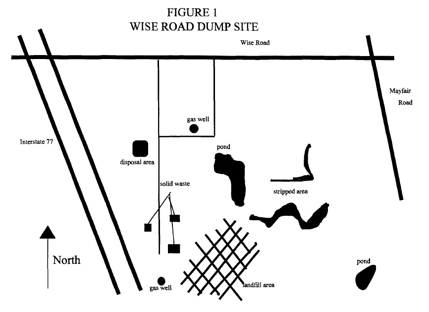
The Wise Road Disposal site is located in an agricultural/rural area in the east central portion
of Green Township, Summit County, south of Wise Road, east of Interstate 77, and west of
Mayfair Road. The property had been used for coal mining activities prior to 1940. The
majority of the site has been extensively quarried for both sand and gravel. The approximate
size of the site is 60 acres. Two quarry pits are located on the eastern portion of the site. The
quarries are each approximately two acres in size and contain very steep banks. The site
access road runs south from Wise Road through the northern portion of the site, then
proceeds south along the eastern side of the site. A natural gas well on-site is located in a
wet and swampy area to the north of the suspected waste deposition area (see figure 1).
Their are a number of small areas of what appears to be household refuse located on the east
side of the access road and in numerous locations on the main fill area. The main fill area
is located east of the road and had been quarried for many years. The numerous waste
streams (from Akron rubber companies) were dumped over the quarry walls and burned.
This area has since been filled and graded. Scrub brush and trees occupy a majority of the
old fill area, some recently deposited household solid waste is prevalent. There are two
remaining quarry pits (ponds) that form the majority of the western boundary of the old fill
area. It appears that the majority of the industrial wastes are located well below the land
surface. The site is currently being used for recreational activities.
|
Section 3.3 Site History:
3.3 Site History
The Wise Road Dump operated under the name of Industrial Disposal Company from 1946
until 1950. Court records indicate that rubber companies sent wastes to the site and it was
burned. This waste included paper, rubber scraps, floor sweepings, and some drummed
chemical wastes. The practice was to dump the waste down the embankment of quarried
areas, or pits, and then burn the wastes. Drums were ignited to destroy the contents prior to
reuse. Some wastes were burned at the top of the pits to remove rubber from steel parts to
be put back into use.
As apparent in the above-mentioned information, the area was also a gravel quarry. The time
period where quarry activities occurred is unknown. Several pits and high walls remain at
the site. Interstate 77 has been constructed near the site after the cessation of the disposal
activities.
Areas around the site have been subject to ongoing residential development through the
years. A golf course has been constructed to the north of the site with several new homes
adjacent to it. All of these new homes utilize ground water for water supplies. The direct
surrounding area to the site is predominantly agricultural with Interstate 77 bordering the site
to the west. The site is used as an unofficial recreational facility.
|
Section 4.1 Groundwater Well Samples:
4.1 Groundwater Well Samples
There were two criteria used when determining which particular wells were to be used as
sampling locations: direct proximity to the site and knowledge of groundwater flow in the
area. There were five drinking water samples collected as part of this investigation. Three
of those samples were obtained from individual residences near the site, which were Samples
EAQL/MEACQl, EAQL/MEACQ2 and EAQL/MEACQ4. While two additional samples
were collected, one from a nearby church (Sample EAQL/MEACQ7) and the other from an
old home foundation area (Sample EAQL/MEACQ3). Both a trip blank and a duplicate of
Sample EAQL/MEACQ2 were collected as part of this sampling activity. These particular
samples were then submitted to Ross Analytical Laboratories for drinking water analyses
(SAS). The analytical results have since been forwarded to U.S. EPA Region V for QAy'QC
validation. These samples were taken to determine the potential for contamination in the
underlying aquifer.
|
Section 5.1 Residential Well Samples:
5.1 Residential Well Samples
There were significant levels of contaminants detected in all the residential well water
samples. Individual residential well sampling data is contained in Table 1. CLP analyses
confirmed the existence of cyanide and ten metals above the MCL's established for public
drinking water supplies, cancer index and the reference dose (RfD) values.
The cyanide and metal analyses included cyanide (10 - 26 ppb), aluminum (162 and 1360
ppb), arsenic (4.8 ppb), barium (59.9 - 4070 ppb), cadmium (2.4 - 74.3 ppb), copper (27.8 -
58.9 ppb), iron (254- 385,000 ppb), lead (2.8 - 70.4 ppb), magnesium (11,700 - 22,000 ppb),
manganese (23.2 - 10,400 ppb), and zinc (15.8 - 1060 ppb).
The only volatile organic compound detected in the residential well samples was 1,2-
dichloroethane in one sample at 1.0 ppb. There were no significant levels of semi-volatile
compounds, PCB's, or pesticides detected in the residential well sample analyses.
|
Section 6.1 Ground Water Pathway:
6.1 Ground Water Pathway
The ground water migration pathway appeared to be the most serious concern at the site. All
of the residences that surround the site currently utilize ground water as their sole source of
drinking water. Approximately ten residences, two churches and a public golf course are
located within one quarter mile of the site. The immediate area around the site is a rapidly
developing residential area. The estimated population within a four mile radius around the
site is 33,424. There are 37 public ground water systems within a four mile radius of the site
serving an estimated population of 24,809 people. This includes the City of North Canton
serving an estimated population of 17,000.
The potential that past disposal practices at the site may have negatively impacted the ground
water beneath and surrounding the site was a serious concern. Some soil contaminants may
pose a possible threat to the groundwater. Due to the unclear history of site activities the
contaminants detected in the nearby wells may or may not be directly related to the site. It
is unclear of the groundwater flow direction at this time. The highest concentration of
contaminates were in the on-site cistern.
|
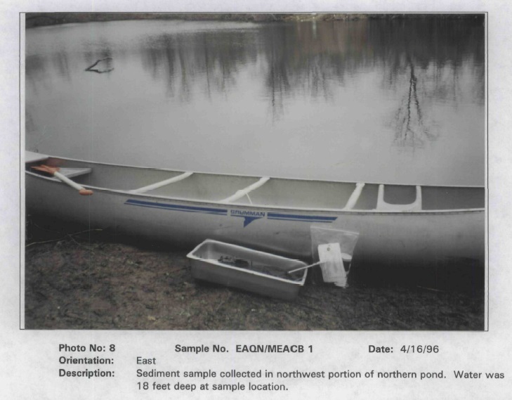
Section APPENDIX E Photo Log, Photo No: 8 indicates that the water is at least
18 feet deep.
The complete 95 page, 25 megabyte EPA document
Integrated Assessment Report for Wise Road Disposal Site,
dated September 30, 1996, is available in:
05-427358.pdf.
The set of images below include the area in Figure 1 above. Select BACK or NEXT to change between
the images to identify the location of the items in Figure 1 to the recent aerial photo that
identifies Ariss Park. Evidently, Figure 1 is not to proper scale:
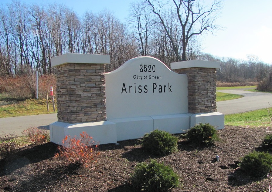
The Ariss Park web site is at:
Ariss Park
Please be sure to see the SOLUTION for Episode 5
of 'The Green History Detectives' to learn about the
IEL Superfund Site, which has been called the third worst Superfund Site in the entire nation,
located less than 4 miles from the WISE ROAD DISPOSAL SITE.